Yunnan Province Map: Where Is Yunnan, China? Cities, Capital & Geography
When I explain Yunnan to foreign friends, I always pull up a Yunnan province map first. Because nine times out of ten, they ask the same thing: “Where is Yunnan? Is it a city?”
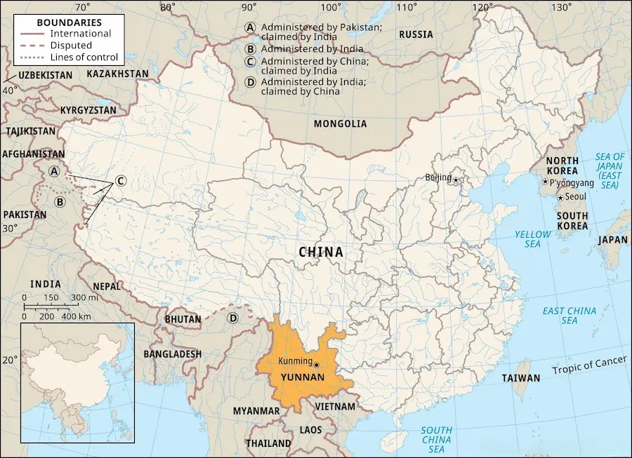
It’s not. Yunnan covers 394,100 square kilometers (152,000 sq mi) — larger than Germany, and about the size of California. Its population sits around 46.9 million. And it hugs the border — to the south it touches Myanmar, Laos, and Vietnam. To find it on a map of Yunnan, slide your eyes to China’s southwest corner. That big block against the frontier? That’s Yunnan (云南, Yúnnán).
- Where Is Yunnan? (Yunnan Province Map & Location)
- Major Cities in Yunnan: Kunming, Dali, Lijiang & More
- Yunnan's Geography: The Plateau, Mountains & Terrain
- How to Use This Yunnan Map to Plan Your Route
- 3 Map Mistakes Travelers Make in Yunnan
- Getting Around Yunnan: A Quick Transport Map
- FAQ: Common Questions About Yunnan
Where Is Yunnan? (Yunnan Province Map & Location)
Yunnan sits in China’s far southwest, a province that stares straight at the border. On any yunnan china map, that’s the first thing you notice — it shares more frontier with Southeast Asia than with the rest of China. To the south, it meets three countries: Myanmar (the longest shared border), Laos, and Vietnam. To the north and east, four Chinese provinces and regions wrap around it — Sichuan to the north, Guizhou to the northeast, Guangxi to the southeast, and Tibet to the northwest.
The capital, Kunming, sits a little east of the center, and it works as the transport heart of this Yunnan map.
After several trips around the province, one thing still gets me: on the map, everything looks close. The moment you climb on a bus, you feel how big Yunnan really is. Driving from Kunming up to Shangri-La, the view outside shifts from basin to snow peaks, and the altitude creeps from 1,900 meters to 3,300 meters before you notice it.
Major Cities in Yunnan: Kunming, Dali, Lijiang & More
Yunnan’s cities don’t bunch together. They spread across four directions, and each direction plays its own game:
- Central (滇中) — Kunming, the capital and the first stop for almost everyone.
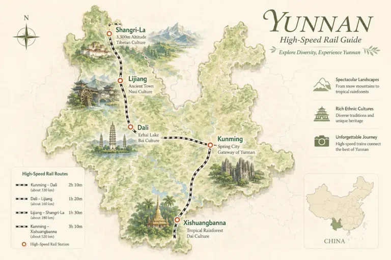
- Northwest (滇西北) — Dali, Lijiang, and Shangri-La. The classic line: snow mountains, old towns, and Erhai Lake.
- South (滇南) — Xishuangbanna (Jinghong) and Pu’er. Rainforest, elephants, and tea country.
- West (滇西) — Tengchong (Baoshan). Hot springs and volcanoes.
- Southeast (滇东南) — Honghe (Yuanyang, Jianshui). Rice terraces and ancient towns.
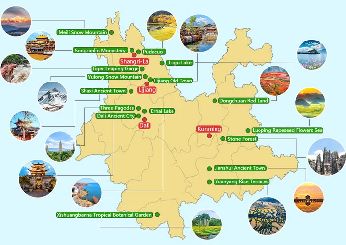
Kunming — the Capital of Yunnan
If you only study one city on the Yunnan map, make it Kunming. It’s the provincial capital, the biggest transport hub, and the city most flights land in. Pull up any Kunming map and you’ll spot Dianchi Lake to the south and the airport to the northeast — the layout that makes it so easy to start every Yunnan trip here. A Kunming map doubles as your first kunming china map: the airport and the two high-speed rail stations are what plug you into the rest of the province.
Keep one rule in your head: northwest for mountains, lakes, and Tibetan culture; south for rainforest and elephants; west for hot springs and the border; southeast for terraces and old towns. Four directions, four different Yunnans. That’s what a proper yunnan china map with cities does for you — it turns a scary-big province into four bite-sized directions. For the full list of stops, see my guide to the best things to do in Yunnan.
Yunnan’s Geography: The Plateau, Mountains & Terrain
Yunnan’s geography, in one line: high in the northwest, low in the southeast. The whole province sits on the Yunnan plateau, with the Hengduan Mountains crowding the northwest corner — around Shangri-La the land sits above 3,000 meters. As you head southeast, the ground drops, until Xishuangbanna feels like full tropical rainforest.
That drop lets one province hold snow mountains, lakes, gorges, and jungle at the same time. Dianchi Lake and Erhai Lake lie in the center and west. The Lancang River runs from the northwest out through the south border — and once it leaves China, it becomes the Mekong.

How to Use This Yunnan Map to Plan Your Route
Once you can read the Yunnan map, planning gets easy. A tourist map that marks these lines saves you days of back-and-forth. Yunnan’s travel routes basically follow a few lines:
- Northwest line (Kunming → Dali → Lijiang → Shangri-La): altitude climbs step by step from 1,900m to 3,300m, all by high-speed rail, 7–10 days. First-timers, this one line is enough.
- South line (Kunming → Pu’er → Xishuangbanna): the China–Laos railway runs straight down, 5–7 days of rainforest, night markets, and Dai culture.
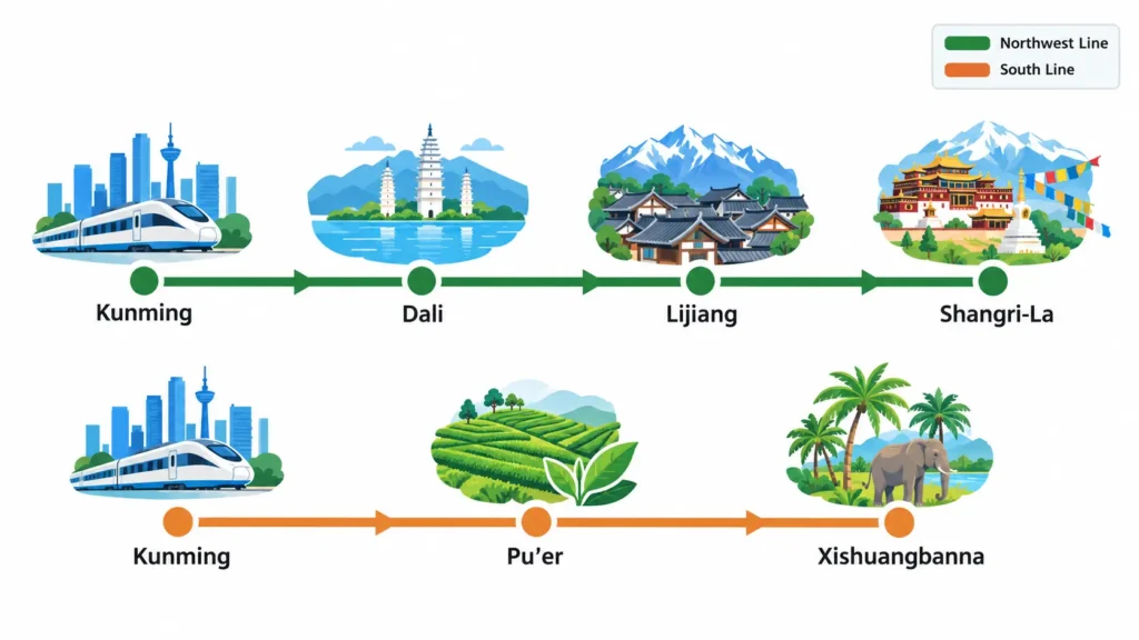
Those are just the two main lines. For the day-by-day plan — where to stay each night, what to squeeze in — I’ve written a full plan your Yunnan itinerary guide, so I won’t repeat it here.
3 Map Mistakes Travelers Make in Yunnan
Mistake one: thinking Yunnan is small. Plenty of people picture it as one city with a few sights, then book three days and expect to see it all. 394,100 square kilometers — larger than Germany. Three days won’t even finish the northwest line.
Mistake two: thinking cities sit close together. On a Yunnan map, Dali and Lijiang look like neighbors. In reality, they’re about 170 km apart; Kunming to Shangri-La runs about 630 km. This is the easiest way a map misleads you — so read travel time, not straight-line distance:
| Route | Distance | Best way | High-speed rail | Bus | Pro tip |
|---|---|---|---|---|---|
| Kunming → Dali | ~330 km | HSR | 2–2.5 h | 4–5 h | Trains run often — skip the bus |
| Dali → Lijiang | ~170 km | HSR | 1.5–2 h | 2.5–3 h | Rail or private car, both fine |
| Lijiang → Shangri-La | ~170 km | HSR | 1.2–1.5 h | 3–4 h | Lijiang–Shangri-La railway now open |
| Kunming → Shangri-La | ~630 km | HSR or flight | 4.5–5.5 h | 8–9 h | Direct flight ≈ 1.5 h |
| Kunming → Xishuangbanna | ~540 km | HSR (China–Laos railway) | 3–4 h | 7–8 h | C/D trains, fast and easy |
Mistake three: reading an admin map instead of a travel map. An admin map tells you where cities are. What a traveler actually needs is how cities connect, and how many days one line takes. That’s exactly why I split this Yunnan province map into a few lines by direction — the kind of yunnan china map you actually want to travel with.
Getting Around Yunnan: A Quick Transport Map
Almost everyone arrives through Kunming. Kunming Changshui International Airport is the province’s biggest international gateway, with flights across Southeast Asia and China. By high-speed rail, Kunming South Railway Station is the inter-province hub — Beijing, Shanghai, Guangzhou, even Vientiane in Laos, all reach it directly.
Inside the province, everything radiates out from Kunming Station and Kunming South: Dali, Lijiang, Shangri-La, and Xishuangbanna all connect by high-speed rail. For the full guide on tickets and which train to take, I’ve put it all in my getting around Yunnan guide — no need to repeat it here.
FAQ: Common Questions About Yunnan
What is Yunnan famous for?
Its mix of ethnic groups, its sharp landscapes (snow mountains and rainforest in one province), plus Pu’er tea and wild mushrooms. Most foreign visitors name Lijiang, Dali, and Shangri-La.
When should I avoid visiting Yunnan?
There’s no truly bad month, but if you only want snow peaks under blue sky, skip the June–August rainy season. For Yuanyang’s rice terraces, wait for the flooded months of December to March. I’ve broken the seasons down in my best time to visit Yunnan guide.
Is Yunnan different from the rest of China?
Yes, in a few ways. It’s home to 25 officially recognized ethnic minority groups, sits at high altitude, and leans toward Southeast Asia. The vibe has its own flavor.
Are Yunnan people Chinese?
They are. Yunnan is a Chinese province; most residents are Han Chinese, alongside those 25 ethnic minority groups.
Next time someone asks you “where is yunnan?”, you won’t need to hunt for a Yunnan map. You’ll already see it — southwest corner, three countries on its southern edge, and four different Yunnans waiting in four directions.

Ke Ping — Founder, Yunnan Travel Tips
Certified China Travel Specialist · Certificate details
This guide can become your real trip. Instead of figuring out complicated logistics alone, let me and our team build your perfect Yunnan journey — from sunrise at Meili Snow Mountain to tea tasting in ancient Dali.
📋 Plan My Yunnan Trip